

River Derwent at Cromford Bridge
We look after Derbyshire's rivers and waterways
Our vision is to create and protect a healthy and wildlife rich water environment within the Derbyshire Derwent Catchment, that will bring social, well-being and economic benefits to all.Derbyshire Derwent Catchment Partnership
Derbyshire Wildlife Trust is the host for the Derbyshire Derwent Catchment Partnership, one of 93 catchment partnerships established across England.
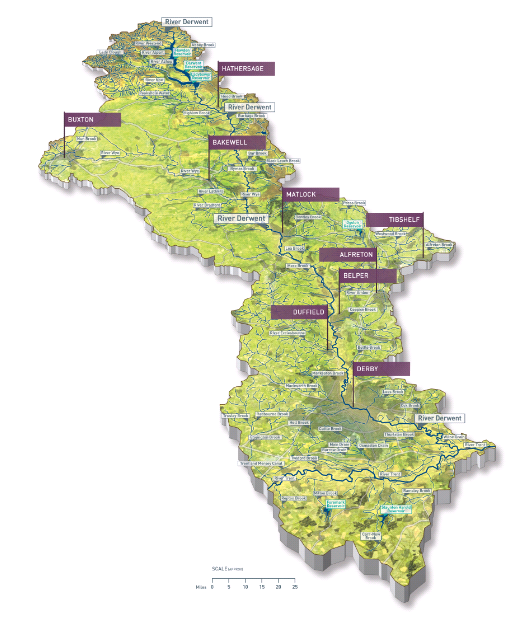
The catchment of the River Derwent covers an area of 1,194km2, covering much of the county of Derbyshire and much of the Peak District National Park. Rising on Howden Moor, tributaries flow into Howden, Derwent and Ladybower Reservoirs, and the water flows south below these reservoirs. This watercourse joins the River Noe - after its journey through Edale - at Bamford. This then becomes the River Derwent and flows though Froggatt, Baslow and Chatsworth Park. At Rowsley, it is joined by the River Wye which has travelled through Buxton, Bakewell and some of the most beautiful dales of the Peak District such as Monsal Dale and Chee Dale. The Derwent continues its course south through Matlock, Belper and then Derby. It finally joins the River Trent to the south west of Long Eaton where it then starts its journey north to the Humber Estuary.
Let us tell you more...
Who's involved?
There are 58 partners in the Derbyshire Derwent Catchment Partnership, including:
Advyce (Transition Belper)
Amber Valley Borough Council
Amber Valley Ramblers
Amber Valley Ramblers
Banks Group
Blackwell Parish Council
British Canoeing
British Geological Survey
Bubnell Fly Fishing Club
Bullbridge and Sawmills Area Civic Society
Campaign for the Farmed Environment
Canal and Rivers Trust
Chatsworth Estate
Cromford Fly Fishers
DEB
Denby Pottery
Derby and Sandiacre Canal Trust
Derby City Council
Derby Railway Angling Club
Derbyshire County Angling Club
Derbyshire County Council
Derbyshire Dales District Council
Derbyshire Dales Ramblers
Derbyshire Wildlife Trust
Derwent Fly Fishing Club
DerwentWISE
Duffield Parish Council
Earl of Harrington’s Angling Club
Ecclesbourne Fly Fishing Club
Ecclesbourne Valley Railway
Environment Agency
Forestry Commission
Friends of Ecclesbourne Way
Friends of Markeaton Brook
Friends of Ripley Greenway
Hanson
Hilcote Environmental Leisure Project
Keep Britain Tidy
Lafarge Tarmac
Lowland Derbyshire Biodiversity Partnership
Matlock Angling Club
Matlock Canoe Club
Moors for the Future
National Farmers' Union
National Trust
Natural England
Old Waltonians Fly Fishing Club
Peak District National Park Authority
Peak Paddlers
Royal Society for the Protection of Birds
Severn Trent Water PLC
The Grayling Society
Trent and Peak Archaeology
Trent Rivers Trust
Turnditch Orchard Project
University of Derby
Wild Trout Trust
Wirksworth Town Council
The first Steering Group meeting was held in March 2015 and these are now held on a quarterly basis.
The Derbyshire Derwent Catchment Partnership Plan has been formulated from all the information that has been gathered from catchment partners over the years. From this, we will prioritise projects, apply for funding and then relevant partners will implement work on the ground.
The Water Framework Directive
The Water Framework Directive (WFD) is European Union legislation which requires all member states to improve the ecological status of their water bodies by 2027. It set measurable standards for water quality and conservation. The WFD regulations were enacted in UK law by the Water Act 2003.
In England and Wales, the Environment Agency is the ‘competent authority’ implementing the obligations of the WFD. This means it takes responsibility for analysis and monitoring of water bodies. It is also responsible for the enforcement of regulation, and for prosecution in the case of non-compliance.
The WFD is an important change in the way we manage our most precious resource. It encourages a holistic approach to water management, by considering not just the watercourses, but the entire landscape of the river basin. This is important, because almost everything that happens on the land has an effect on the water. Products of transport, agriculture, urban and industrial activity all run into the river.
River Basin Management Plans (RBMPs) work on making the whole river environment healthier, which doesn’t just improve the water quality, it also makes the whole area better able to cope with changes in the future. RBMPs also include regular monitoring and review processes, an essential part of all good management plans.
River Ecclesbourne Restoration Project
The Ecclesbourne flows for around nine miles, disappearing underground in places, from the market town of Wirksworth until it meets the River Derwent near Duffield. It is popular with walkers who enjoy a stroll along its banks and with anglers who enjoy the appeal of the river’s brown trout population. The river supports a variety of wildlife including some important species such as white-clawed crayfish, mayflies, kingfishers and water voles, but it is facing challenges including pollution and weirs which prevent fish from migrating.
In 2022, work was undertaken by the Environment Agency and the Wild Trout Trust to remove Snake Lane Weir, Duffield, and open up the river further for fish migration. Following this success, the one remaining impassible weir on the river Ecclesbourne will be bypassed in Autumn 2023. Here, the original river channel will be excavated, allowing for the main watercourse to flow through it once more, bypassing the weir at the site of the former Postern Mill.
To find out more about the Ecclesbourne Restoration Project click the links below:
Catchment Maps
Catchment maps displaying the latest Environment Agency classification for the individual water bodies in the Derbyshire Derwent are available at the Environment Agency’s Catchment Data Explorer.
The Catchment Data Explorer is designed to help you explore and download information about the water environment used in the consultation on the updates to the River Basin Management Plans. You can find catchments and water bodies of interest using a map, or by searching for names, view summary information about catchments, download data and follow links to other useful sites.
If you would like to find out more about the Derbyshire Derwent Catchment Partnership or tell us about a project/event you’re planning or would like to get off the ground, please email us at livingrivers@derbyshirewt.co.uk
- Upper Derwent Map 2015 (2.16 MB)
- Mid Derwent Map 2015 (2.14 MB)
- Lower Derwent Map 2015 (1.42 MB)
Downloads
Leaflets
River and Catchment Restoration Downloads
Documents
- Catchment Management Plan.pdf (165.74 KB)
Derbyshire's River Derwent, Now and Forever, Jack Perks