Mapping Derbyshire’s Peatlands: Nature’s Climate Solution

Mapping Derbyshire’s Peatlands: Nature’s Climate Solution

Mark Hamblin/2020 VISION

Our peatlands might look like soggy moorland, but they’re incredible carbon storage systems – locking away greenhouse gases and supporting rare wildlife. Thanks to the new England Peat Map, we now know exactly where these precious habitats are and how healthy they are.

At first glance, peatlands might not seem very exciting, they’re often soggy, windswept areas hidden away in the hills. But beneath the surface, they’re one of nature’s most powerful tools in the fight against climate change. That’s because peat is made up of partly decayed plants that have built up over thousands of years, locking away huge amounts of carbon.

Thanks to a newly updated dataset from Natural England, called the England Peat Map, we now have the most accurate picture yet of where these landscapes are, how healthy they are, and how much carbon they can store.

What is the England Peat Map?

The England Peat Map, released earlier this year, is the most detailed picture of peat soils ever created in the UK. It took five years of work by scientists, ecologists, and data experts, who combined information from satellites in space, surveys on the ground, and computer models (a type of machine learning that spots patterns in big sets of data). Together, this revealed where peatlands are found, how deep the peat goes, and what plants are growing on top.

This map is already proving useful. Conservation groups, farmers, and land managers are using it to make better decisions about how to protect these carbon-rich soils and restore damaged areas.

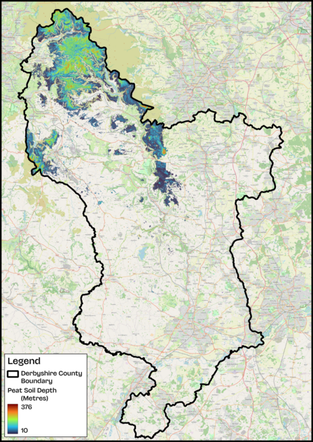
Derbyshire Peat Map

What did it reveal about Derbyshire?

Derbyshire is home to almost 35,000 hectares of peatland – most of it spread across the Peak District National Park. To put that into perspective, that’s over 13% of the county’s soil, making it one of Derbyshire’s greatest natural assets.

Some standout findings from the new map:

  • 61% of Derbyshire’s peat lies beneath Calluna bog – that means large areas are dominated by heather plants, which thrive in these wet, acidic soils.
  • 96% of peat is found in bog environments. Bogs are especially valuable because they act like natural carbon vaults, storing greenhouse gases while also providing a home for rare wildlife.
  • Peat depth varies a lot – from as little as 10cm (about the length of a pencil) to nearly 5 metres (taller than a double-decker bus). The average is 84cm, but shallow peat is at risk of drying out or being washed away.
  • The map is highly reliable, with an accuracy of over 90% in most areas – giving land managers confidence that they can trust and use the data.

How does this link to our work?

At Derbyshire Wildlife Trust (DWT), we’re using the new peatland data to guide our work through the Derwent Living Forest Programme. Our main goal is to support farmers with clear information and funding opportunities so they can adopt wetter farming or restore peatlands. By working directly with farmers, we can help protect these fragile habitats while keeping farms productive.

Through our COOP Carbon Innovation project, we’re exploring whether it’s possible to restore peatlands while maintaining or improving farm income and food production. This could mean:

  • Farming in nature-friendly ways, like reducing ploughing and planting cover crops.
  • Diversifying income with tree crops for nuts or hedgerows for berries.
  • Accessing green finance, which is funding aimed at supporting land management that improves climate resilience, biodiversity, and water quality, while allowing food production to continue outside the peatland areas.

We’re also testing remote sensing technology, using satellites, drones, and other tools to monitor peatlands over time. This helps us improve the accuracy of peat mapping and could make farmland more attractive to investors by lowering the cost of monitoring under green finance agreements.

The England Peat Map is a great starting point, but we’re also conducting ground surveys to double-check and fine-tune the data. By combining cutting-edge technology with hands-on restoration, we’re helping Derbyshire’s peatlands thrive. Every metre of healthy peat means more carbon locked away, more wildlife supported, and greater resilience for future generations.